Doonia
NEW GOLD PROJECT IN THE EASTERN GOLDFIELDS OF WA
- Impact acquires 80% interest in a drill-ready gold project 75 km east of Kambalda in the Mt Belches Basin.
- Significant gold-in-soil anomaly 2.5 km long and up to 1 km wide located over numerous small prominent magnetic anomalies.
- Associated multi-metal anomalism suggests an intrusion-hosted gold target.
- Significant gold-in-regolith anomaly from very wide spaced shallow aircore drilling in the 1990’s not followed up at depth.
- Clearly defined target for immediate drill testing after grant of tenement.
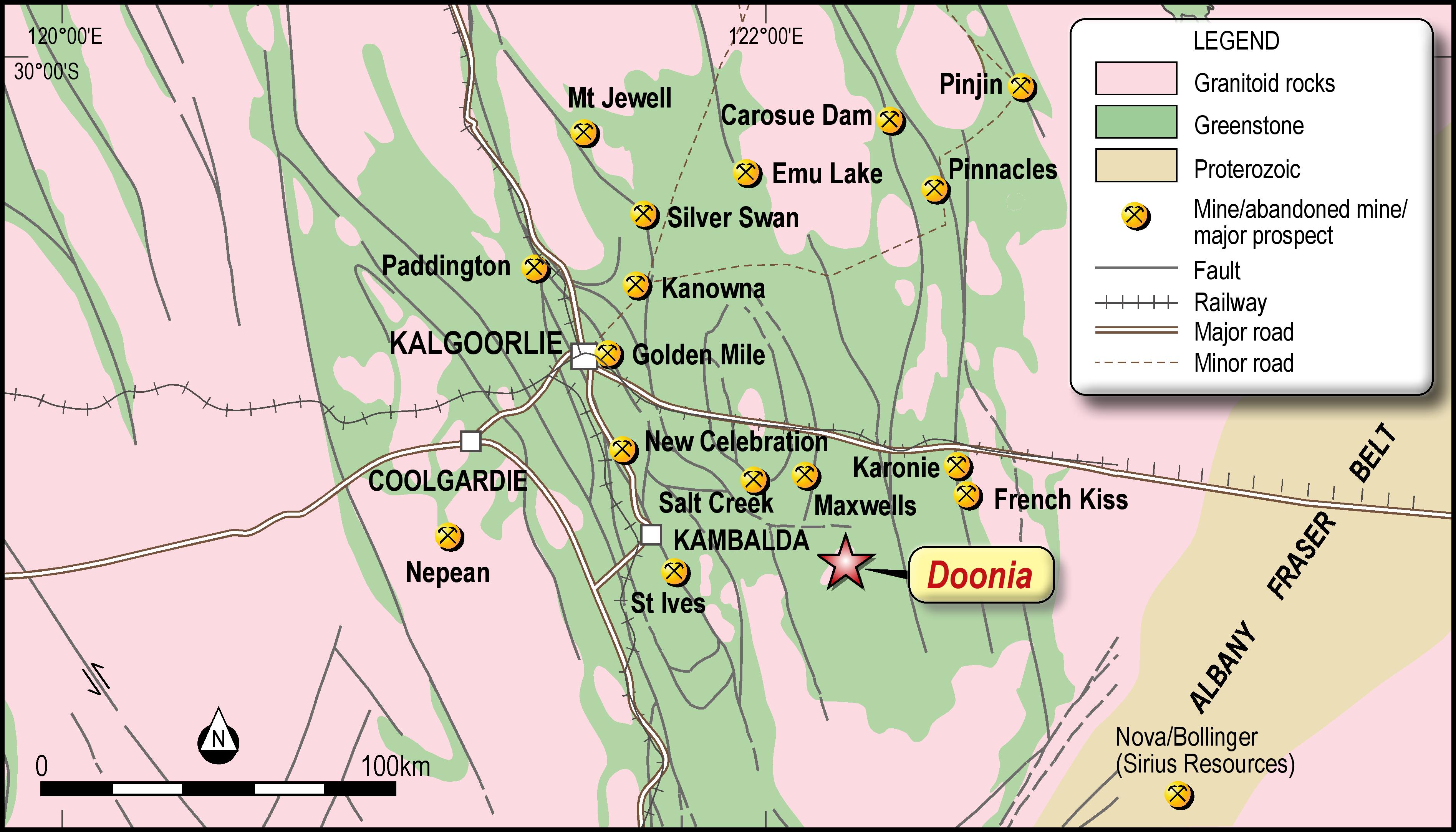
Figure 1. Location of the Doonia Project in the Eastern Goldfields of Western Australia.
Impact Minerals Limited (ASX:IPT) is pleased to announce that it has entered into a joint venture over the Doonia project located 75 kilometres east of Kambalda, home to the world class St Ives gold mining centre in Western Australia (Figure 1).
The target was identified following a review of the Eastern Goldfields for intrusion-hosted gold deposits in light of the Hemi discovery in the Pilbara where a major gold deposit hosted by felsic intrusions has recently been outlined by De Grey Mining Limited.
Impact Minerals Managing Director, Dr Mike Jones:
“Doonia is a highly prospective addition to our exploration portfolio and we acted very quickly when alerted to the opportunity. We now have an exploration project with excellent indications for the discovery of a significant gold deposit with a target that is already well defined, easily manageable and cheap to test.
The large surface geochemistry gold anomaly has been very poorly drilled and we will endeavour to do that as quickly as practicable after our tenement is granted early in 2021.”
“The recent discovery at Hemi is a classic example of “you don’t find what you don’t look for”, where for decades it was considered that a deposit of that size and scale was unlikely to be found in the Pilbara Craton.
“There is a good chance that Doonia may also be an “out-of-the-box” discovery” Dr Jones said.
Previous Exploration at Doonia
A total of 721 soil geochemistry samples were taken over the Doonia project in 1999 by WMC Resources Limited at an initial spacing of 800 metres by 200 metres with subsequent infill at a spacing of 200 metres by 200 metres between samples. Two encouraging gold-in-soil anomalies were defined and tested by 49 aircore holes to an average depth of 28 metres (minimum depth 3 metres, maximum depth 52 metres).
Interpretation of the Soil Geochemistry Data
The soil geochemistry results returned values of up to 8 ppb gold, 8.4 ppb bismuth, 440 ppm nickel,
and 90 ppm copper (Table 1).
Although these absolute values are modest, the entire area is underlain by stabilised sandy soils and colluvium on the southern margin of a broad salt lake system. It is well known that such sandy soils may significantly dilute soil geochemistry responses and background values are estimated to be less than 10 ppm for nickel and copper and no more than 1 ppb for gold and bismuth. The maximum values are therefore well above background and of exploration significance, in particular given a previously unrecognised well-developed zonation pattern that is evident in the data (Figures 2 and 3).
The results of the soil geochemistry survey are presented as additive Z score indices in Figures 2 and 3. Z scores are a standard statistical calculation of the number of standard deviations a raw data (assay) value is from the mean of the data. For example, a Z score of 2 indicates a value 2 standard deviations above the mean. The higher the Z score, the more anomalous the data point is with respect to the dataset. The mean for each of the metals of interest described here is also listed in Table 1.
Z scores are a standard method of normalising data so that statistically meaningful associations between datasets can be made. In this case the Z scores for individual metals that are commonly associated around gold deposits are simply added together in order to amplify the association. For example, the Z scores for gold and bismuth may be added together to help define the core of an intrusive related gold system.
Zoned Soil Geochemistry Anomaly
The soil geochemistry results reveal a very distinct and coherent zoned geochemical anomaly that was not recognised by WMC (Figures 2 and 3).
A core area of gold+bismuth 2,500 metres long and up to 1,000 metres wide occurs in the centre of the project area and is surrounded by a larger, (albeit somewhat discontinuous) halo of arsenic+antimony (Figures 2 and 3).
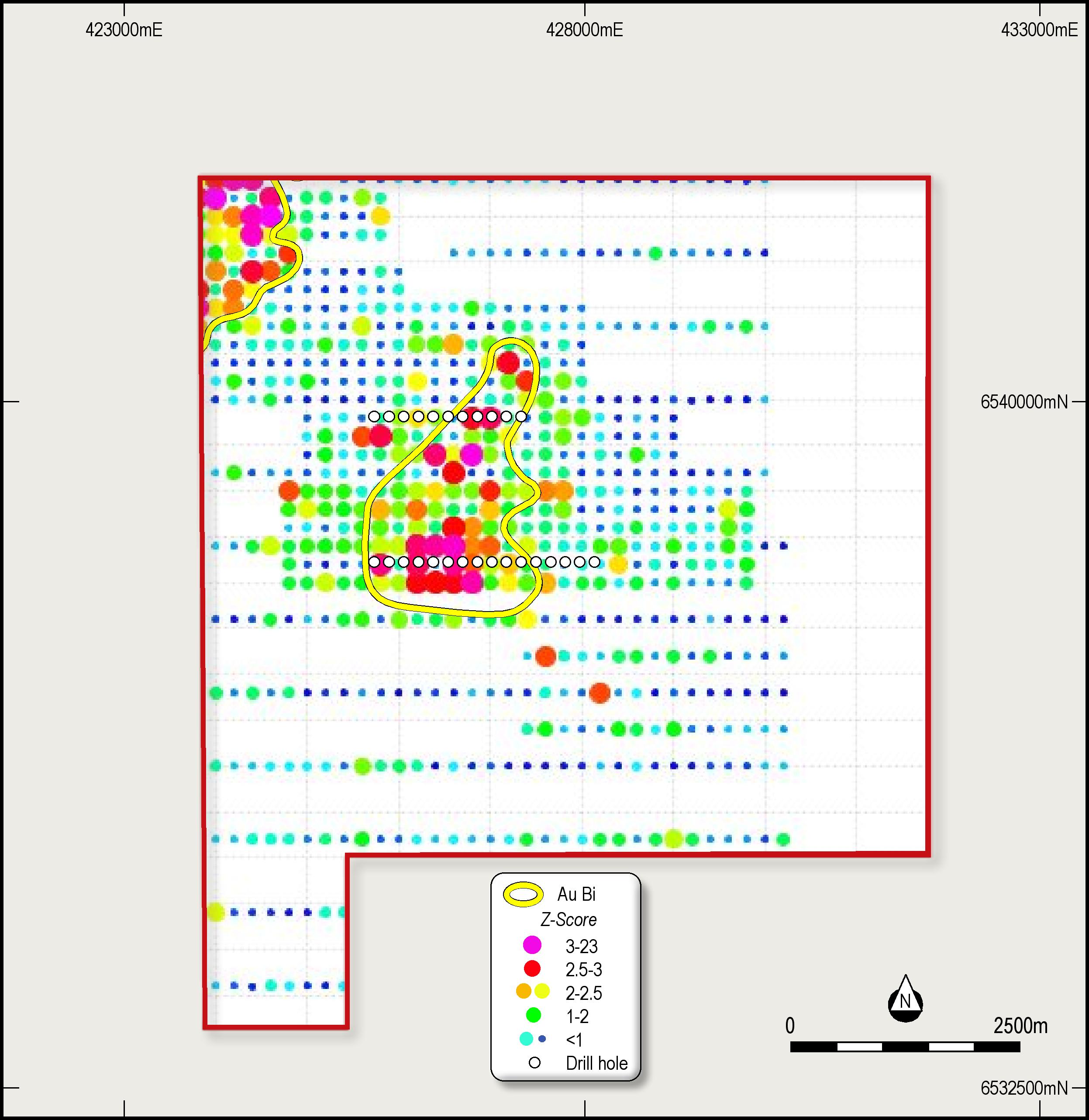
Gold+Bismuth
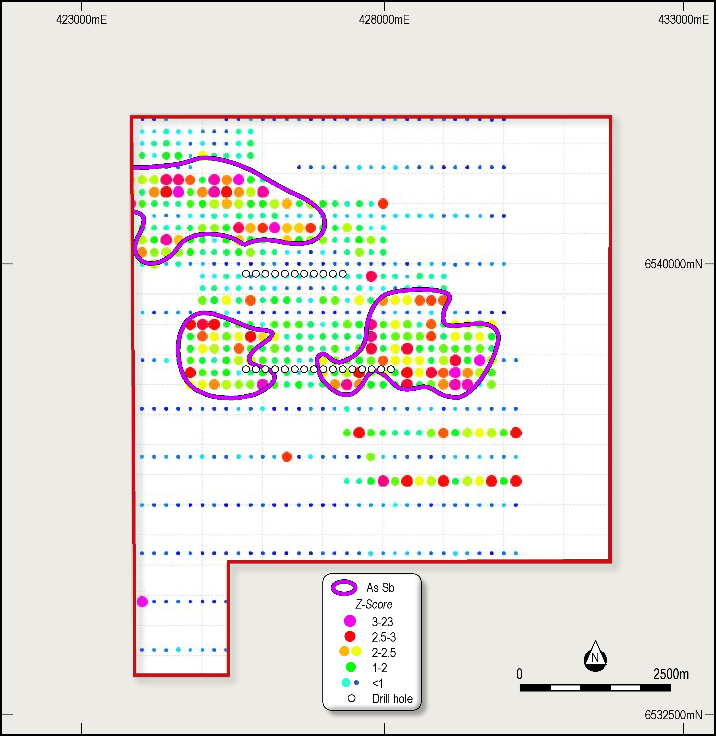
Arsenic+Antimony
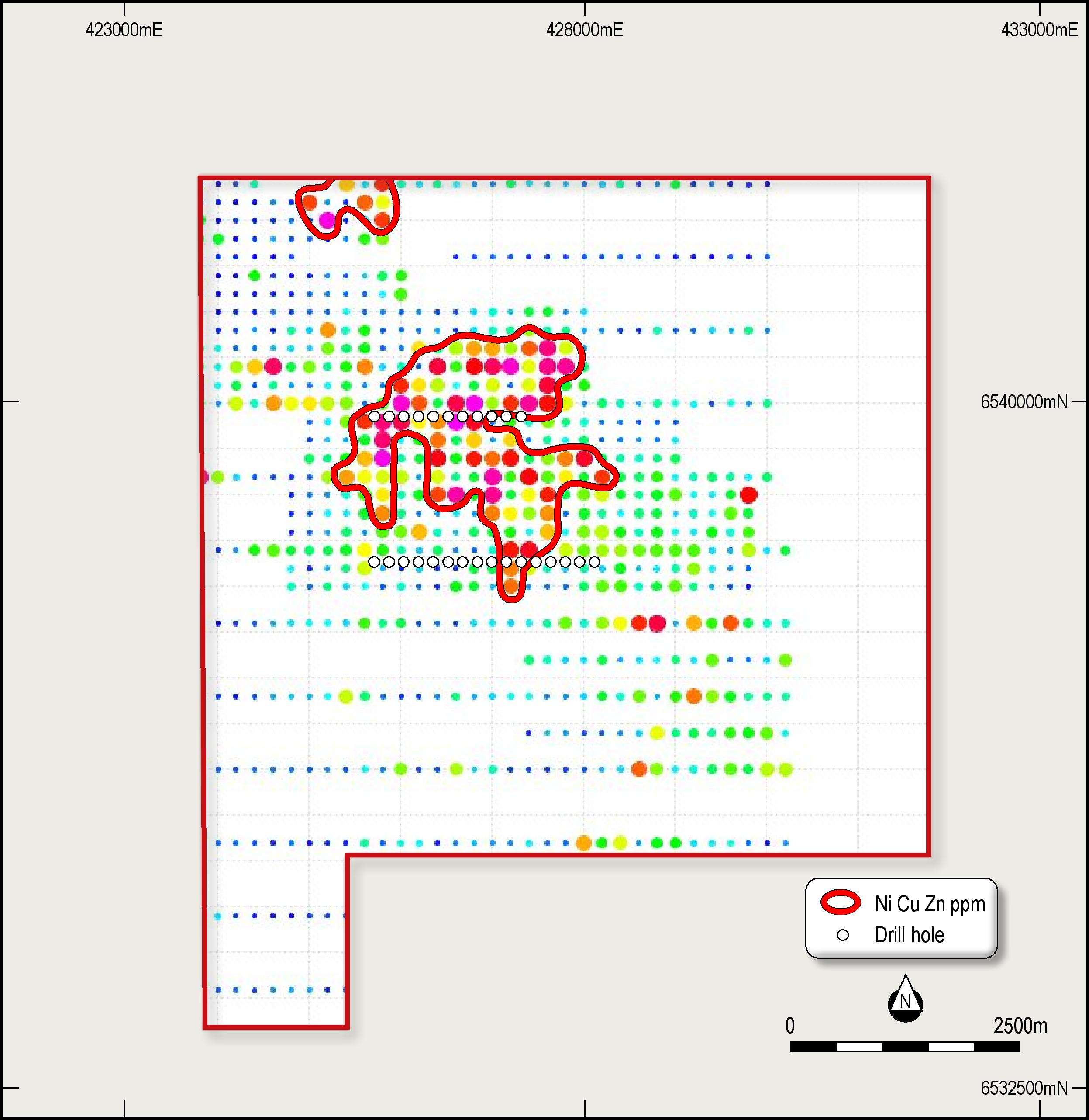
Nickel+Copper+Zinc
Figure 2. Images of the Z-Scores for gold+bismuth, arsenic+antimony and nickel+copper+zinc. Note that the entire central zoned anomaly extends over several square kilometres.
Figure 3. Images of regional magnetic data showing the zoned soil geochemistry pattern with a core of gold+bismuth and an outer halo of arsenic+antimony centred over numerous magnetic anomalies. The left hand image shows a vertical derivative of the magnetic data and the right hand image a total magnetic intensity image. The nickel+copper+zinc anomaly is well developed over the magnetic anomalies and may reflect a buried intrusion.
The gold+bismuth zone overlies numerous small magnetic anomalies visible in regional magnetic data which are also coincident with a nickel+copper+zinc-in soil anomaly that covers an area of about 2,500 metres by 2,000 metres (Figures 2 and 3).
These results are interpreted to be potentially related to a gold-bismuth mineralised system associated with a differentiated mafic to felsic intrusion. The system covers a large area and clearly has the scale to warrant exploration. A second gold+bismuth anomaly is also present in the north west corner of the project area.
Previous Drill Results
The main soil geochemistry anomaly was tested by 27 aircore vertical drill holes by WMC Resources Ltd to an average depth of only 36 metres on two traverses 600 metres apart with holes 160 metres apart. The drilling was limited to weathered rocks and fresh rock was rarely encountered.
Four drill holes on the southern traverses returned significant thicknesses of modest gold mineralisation in the weathered zone as follows (Figure 3).
SAL661 returned 14 metres at 35 ppb gold from 32 metres depth;
SAL663 returned 20 metres at 32 ppb from 32 metres;
SAL657 returned 14 metres at 35 ppb from 32 metres; and
SAL658 returned 6 metres at 23 ppb from surface.
A total of 22 holes were drilled to test the second gold-bismuth anomaly and modest copper results were returned from a few holes.
Previous work by Impact has shown that sub-surface gold (and other metal) dispersion halos in weathering environments close to the margins of salt lakes such as at Doonia, are commonly severely depleted and chemically eroded away by acidic ground water flow. Therefore, close spaced drilling to fresh bedrock is required to adequately test gold-in-soil anomalies in such geochemical environments.
Accordingly, the results of the previous drilling, in combination with the zonation pattern evident in the soil geochemistry data, are considered to be very encouraging given the regolith conditions and the very wide drill spacing used. Deep drilling is required to effectively test the target.
Next Steps
The tenement application (E15/1790) is now pending grant, a process expected to take about 4 months. Upon grant Impact will complete further detailed soil geochemistry surveys to define specific drill targets for immediate follow up.
Further details on the transaction
The Doonia project was brought to Impact’s attention by Milford Resources Pty Ltd (Milford). Milford will be paid $3,750 cash and will be issued 353,829 shares as a finders fee. In addition, a further payment of $10,000 in Impact shares will be made to Milford upon grant of the tenement with the number of shares to be issued calculated on the 10 day VWAP of Impact’s shares prior to the date of grant.
Impact has formed an unincorporated joint venture over the Doonia Project with Odette Resources Pty Ltd (Odette), a party related to Milford Resources Pty Ltd, in which Odette will have a a free carried interest of 20% up to a Decision to Mine. Impact will have an immediate 80% interest in the project on grant of the tenement. At a Decision to Mine Odette can either contribute to future costs on a pro-rata basis or convert its interest to a 1% Net Smelter Royalty.
OTHER PROJECTS
Broken Hill
Impact’s drill programme at Broken Hill is on-going.
Statutory approvals have been received for follow up drilling to commence at the Plat Central prospect to track the recently identified copper-nickel-PGE-bearing basal channel in the host ultramafic unit to the north and south (ASX Release 21st October 2020). Assays from this area are due next week and this will help further define the relationship between the PGE grades and Impact’s proprietary ratio which was used to help define the channel structure.
In addition, drilling is still in progress at the Little Broken Hill Gabbro. Encouraging indications of copper-nickel and possibly PGE’s have been discovered in a few places and assays from several holes have been fast tracked to the laboratory to help confirm this. The samples will be prioritised over other samples Impact has currently awaiting assay.
Assays are also due soon for Dora East and Red Hill.
Commonwealth
The ground IP survey commissioned over the Apsley porphyry copper-gold target was recently completed. The survey was extended several times because of encouraging results coincident with the significant soil geochemistry results reported previously (ASX Release 10th August 2020).
Final data will be received within two weeks. However, the results indicate drill targets are present and fast tracking of the statutory approvals required for drilling are now underway with a view to drilling as soon as practicable, likely to be early in 2021.
COMPLIANCE STATEMENT
This report contains Exploration Results for previous soil geochemistry surveys and 65 drill holes that have not been reported in accordance with the JORC 2012 Code. Details are provided in the drill table and the JORC table below.
The review of exploration activities and results contained in this report is based on information compiled by Dr Mike Jones, a Member of the Australian Institute of Geoscientists. He is a director of the company and works for Impact Minerals Limited. He has sufficient experience which is relevant to the style of mineralisation and types of deposits under consideration and to the activity which he is undertaking to qualify as a Competent Person as defined in the 2012 edition of the Australasian Code for Reporting of Exploration Results, Mineral Resources and Ore Reserves (the JORC Code). Mike Jones has consented to the inclusion in the report of the matters based on his information in the form and context in which it appears.
- Table 1. Summary of Soil Geochemistry Results
| Value |
Au_ppb |
Bi_ppm |
Ni_ppm |
Cu_ppm |
Zn_ppm |
As_ppm |
Sb_ppm |
| Minimum |
0.5 |
0.05 |
60 |
24 |
25 |
2 |
0.05 |
| Maximum |
8 |
8.5 |
440 |
90 |
145 |
15 |
1 |
| Mean |
1.87 |
0.4 |
113.52 |
57.95 |
67.21 |
7.48 |
0.31 |
- Table 2. Drill Hole Table
| HOLE_ID |
COL_EAST |
COL_NORTH |
COL_RL |
COL_AZ |
COL_DIP |
EOH_DEPTH |
| SAL648 |
427520 |
6538080 |
320 |
0 |
-90 |
40 |
| SAL649 |
427680 |
6538080 |
320 |
0 |
-90 |
40 |
| SAL650 |
427840 |
6538080 |
320 |
0 |
-90 |
30 |
| SAL651 |
425760 |
6538080 |
320 |
0 |
-90 |
25 |
| SAL652 |
425920 |
6538080 |
320 |
0 |
-90 |
43 |
| SAL653 |
426080 |
6538080 |
320 |
0 |
-90 |
52 |
| SAL654 |
426240 |
6538080 |
320 |
0 |
-90 |
36 |
| SAL655 |
425600 |
6538080 |
320 |
0 |
-90 |
41 |
| SAL657 |
427040 |
6538080 |
320 |
0 |
-90 |
40 |
| SAL658 |
427200 |
6538080 |
320 |
0 |
-90 |
25 |
| SAL659 |
427360 |
6538080 |
320 |
0 |
-90 |
43 |
| SAL660 |
428000 |
6538080 |
320 |
0 |
-90 |
44 |
| SAL661 |
426400 |
6538080 |
320 |
0 |
-90 |
46 |
| SAL662 |
426560 |
6538080 |
320 |
0 |
-90 |
50 |
| SAL663 |
426720 |
6538080 |
320 |
0 |
-90 |
45 |
| SAL664 |
426880 |
6538080 |
320 |
0 |
-90 |
45 |
| SAL665 |
425600 |
6539680 |
320 |
0 |
-90 |
49 |
| SAL666 |
425760 |
6539680 |
320 |
0 |
-90 |
28 |
| SAL667 |
425920 |
6539680 |
320 |
0 |
-90 |
29 |
| SAL668 |
426080 |
6539680 |
320 |
0 |
-90 |
31 |
| SAL669 |
426240 |
6539680 |
320 |
0 |
-90 |
32 |
| SAL670 |
426400 |
6539680 |
320 |
0 |
-90 |
33 |
| SAL671 |
426560 |
6539680 |
320 |
0 |
-90 |
41 |
| SAL672 |
426720 |
6539680 |
320 |
0 |
-90 |
35 |
| SAL673 |
426880 |
6539680 |
320 |
0 |
-90 |
17 |
| SAL674 |
427040 |
6539680 |
320 |
0 |
-90 |
23 |
| SAL675 |
427200 |
6539680 |
320 |
0 |
-90 |
20 |
| SAL676 |
424000 |
6540960 |
320 |
0 |
-90 |
21 |
| SAL677 |
424160 |
6540960 |
320 |
0 |
-90 |
31 |
| SAL678 |
424320 |
6540960 |
320 |
0 |
-90 |
46 |
| SAL679 |
424480 |
6540960 |
320 |
0 |
-90 |
38 |
| SAL680 |
424640 |
6540960 |
320 |
0 |
-90 |
34 |
| SAL681 |
424800 |
6540960 |
320 |
0 |
-90 |
38 |
| SAL688 |
423840 |
6540960 |
320 |
0 |
-90 |
18 |
| SAL689 |
423680 |
6540960 |
320 |
0 |
-90 |
4 |
| SAL690 |
423520 |
6540960 |
320 |
0 |
-90 |
4 |
| SAL691 |
423360 |
6540960 |
320 |
0 |
-90 |
7 |
| SAL692 |
423200 |
6540960 |
320 |
0 |
-90 |
34 |
| SAL693 |
423520 |
6541920 |
320 |
0 |
-90 |
13 |
| SAL694 |
423680 |
6541920 |
320 |
0 |
-90 |
3 |
| SAL695 |
423840 |
6541920 |
320 |
0 |
-90 |
31 |
| SAL696 |
424000 |
6541920 |
320 |
0 |
-90 |
4 |
| SAL697 |
424160 |
6541920 |
320 |
0 |
-90 |
7 |
| SAL698 |
424320 |
6541920 |
320 |
0 |
-90 |
4 |
| SAL699 |
424480 |
6541920 |
320 |
0 |
-90 |
5 |
| SAL700 |
424640 |
6541920 |
320 |
0 |
-90 |
13 |
| SAL709 |
424800 |
6541920 |
320 |
0 |
-90 |
23 |
| SAL710 |
423360 |
6541920 |
320 |
0 |
-90 |
9 |
| SAL711 |
423200 |
6541920 |
320 |
0 |
-90 |
28 |
| SAL712 |
423200 |
6542880 |
320 |
0 |
-90 |
28 |
| SAL713 |
423360 |
6542880 |
320 |
0 |
-90 |
28 |
| SAL714 |
423040 |
6542880 |
320 |
0 |
-90 |
24 |
| SAL715 |
424160 |
6542880 |
320 |
0 |
-90 |
5 |
| SAL716 |
424320 |
6542880 |
320 |
0 |
-90 |
26 |
| SAL717 |
424480 |
6542880 |
320 |
0 |
-90 |
15 |
| SAL718 |
424640 |
6542880 |
320 |
0 |
-90 |
18 |
| SAL719 |
423520 |
6542880 |
320 |
0 |
-90 |
34 |
| SAL720 |
423680 |
6542880 |
320 |
0 |
-90 |
34 |
| SAL721 |
423840 |
6542880 |
320 |
0 |
-90 |
34 |
| SAL722 |
424000 |
6542880 |
320 |
0 |
-90 |
34 |
| SAL723 |
422880 |
6542880 |
320 |
0 |
-90 |
32 |
| SAL724 |
423940 |
6543450 |
320 |
0 |
-90 |
37 |
| SAL725 |
424100 |
6543450 |
320 |
0 |
-90 |
37 |
| SAL726 |
424260 |
6543450 |
320 |
0 |
-90 |
40 |
| SAL727 |
424420 |
6543450 |
320 |
0 |
-90 |
28 |